Traffic Survey with UAS (Drones)
Drones vs. Traffic Cams/Air Hoses - Take Your Pick!
Pole mounted traffic cameras, air hoses and visual observers all have a place in gathering traffic conditions. They are a low-cost solution for basic Traffic Impact Analysis (TIA). However, when you really need to understand the cause and effect of traffic congestion, near-miss situations and scale of traffic back-up all simultaneously, PERSPECTIVE is everything. Data collection through modern UAS (Unmanned Aerial Systems) has the edge over traditional traffic survey techniques in all aspects. Our aerial services allow Traffic Engineers to get around the constraints that come with fixed cameras and human counting errors. Our services significantly enhance the billable project scope that will have your clients asking to add these services. It will lower your time on analysis and turbocharge your reports and presentations. After all the saying holds true “If a picture is worth a thousand words, then an aerial video is worth a million”. Since we require no infrastructure or pole, we can capture data at all locations- freeways, highways, bridges, or midblock locations with no nearby poles.
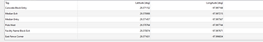
Click To Enlarge
Better Perspective
When analyzing traffic flow and bottleneck locations PERSPECTIVE is everything. FORCE can survey Intersection Turning Movements, Main Lane & Tube Volume, Straight Lane Speeds, Curve Speeds, Traffic Classifications, Blockage-Clearance Times, etc. These services allow you to provide better and safer traffic solutions.
Wider Coverage
Our state-of-the-art UAS with wider field of views allow our analytics team to provide much more contextual data. Imagery and footage by our UAS allow traffic engineers to have wider spatial coverage than traditional traffic cameras attached to poles or stands. Cost conscious service packages provide as much or as little data as needed for project success.
Having better perspective and wider coverage simply means more useful traffic data!
Data Processing & Analysis
No conventional traffic survey team can provide real-time traffic data analysis. If you need real-time traffic data for any location, we can deploy and set up within then hours of proposal approval. Time-sensitive information can only be captured with quick-response time and immediate commencement of data collection with UAS.
High Quality Data ≤ 6K Resolution
FORCE ensures that our clients receive 1080P video resolution standard and up to 6K video if needed. Crystal clear video with multiple Vantage Points. This saves a time for Traffic Engineers who can start using our traffic data for design, modeling and reports and less time analyzing data collected.
Click To Enlarge
Real-time & High Quality data can only be captured by a rapid-response team with state-of-the-art UASs (drones)!
Enhanced Accuracy
Using drones for data collection enables us to monitor simultaneous traffic movements in multiple roads, highways, freeways, and arterials. Hence, our traffic count and volume calculation of main lane, tube volume, diverging and merging traffic and turning movements is near-perfect. Our dedicated team of licensed drone pilots and civil engineers validate the traffic analysis before preparing the reports for our clients.